Mt Clermont Gold Project
Location and Tenure
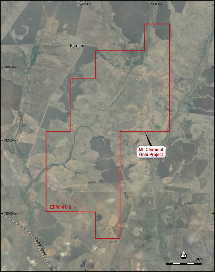
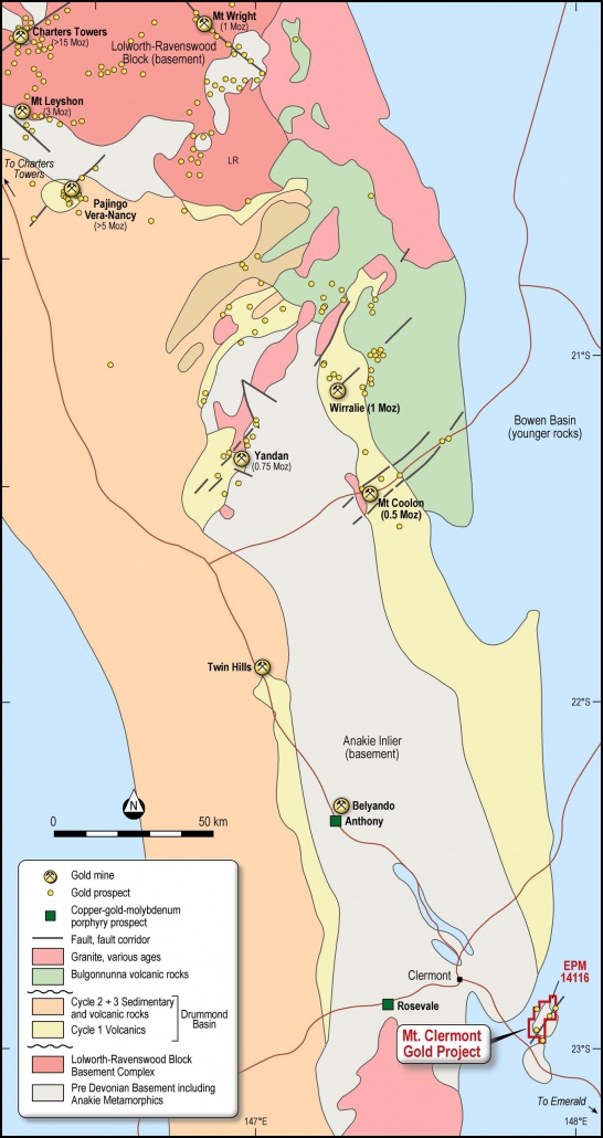
The Clermont Project, EPM 14116 (Figure 10) is located in the southern part of the Drummond Basin in Central Queensland, approximately 60 km by road north-west of the town at Emerald and 330 km from the nearest regional port at Rockhampton (Figure 11).
The Mt Clermont tenement is accessible by well-maintained gravel tracks leading off the nearby bitumen Gregory Highway linking Clermont to Emerald. Access is possible all year except after occasional summer tropical storms when roads may be blocked due to flooding for short periods.
Figure 10: Mt Clermont tenement – EPM 14116. (after GoogleEarth)
Figure 11: Mt Clermont location.
Physiography and climate
The Clermont region that includes the project area comprises a mature continental landscape composed of eroded rounded hills and plains. The climate is subtropical without a distinct dry season, although most rain falls during the summer. The average annual rainfall is about 640 mm (Bureau of Meteorology, 2014).
The Mt Clermont tenement covers predominantly flat, cleared pastoral land dissected by Retro Creek. The district was part of the Brigalow Development Scheme in the 1960s with large-scale clearing of the brigalow scrub by mechanical means. The large new farming blocks opened up by the clearing of the brigalow lent itself to the broad land growing of grain and cereal crops, particularly sunflower and sorghum.
Emerald, 60 km to the southeast, has a humid subtropical climate with hot, relatively wet summers and mild, dry winters. Maximum temperatures range from 34 °C in January to 22 °C in July, while minimums range from 22 °C to 7 °C. The average annual rainfall is 641 mm. The wettest year on record was 1407.2 mm in 1956. Extremes of temperature have ranged from 48.6 °C to −5.6 °C, while the wettest 24 hours on record was 182.0 mm on 25 February 1975.
Regional Geology
The Clermont Project lies within the Anakie Province of the Drummond Basin of central Queensland which is composed of a sequence of Devonian to Carboniferous volcanics and sediments.
The Anakie Province contains predominantly metamorphic rocks of Neoproterozoic – early Palaeozoic age that are assigned to the Anakie Metamorphic Group (Figure 12).
The Anakie Metamorphic Group includes mica schist, quartzite, meta-arenite and greenstone. Three major deformations and subsequent minor folding events have affected the metamorphic rocks. The first deformation produced a strong foliation parallel to relict bedding. Bedding is best preserved in the thinly bedded quartzite units, which are deformed by tight asymmetric second-generation folds. Within metapelites, the first-generation fabric is strongly overprinted by a second-generation layer differentiated crenulation cleavage that is axial planar to tight second-generation folds. The third period of deformation produced north-east-trending upright folds that are overprinted by later more open east-trending regional folds and some south-east-trending folds. Metamorphism was of the low pressure-high temperature type, accompanied the first and second deformations, and ranged from greenschist to amphibolite facies. The depositional age of the Anakie Metamorphic Group is uncertain although K–Ar age dating suggests that the rocks were deformed and metamorphosed at ~510 Ma (Withnall & others, 1996).
The metamorphic rocks of the Anakie Province are intruded by a large composite assemblage of Middle – Late Devonian mainly I-type granitoids of the Retreat Batholith. Rock types range in composition from diorite through monzodiorite and granodiorite to granite. Rb-Sr ages range from 366 Ma to 385 Ma.
Volcanic rocks consisting predominantly of mafic lavas and lesser volcaniclastics assigned to the Theresa Creek Volcanics unconformably overlie the Anakie Metamorphic Group (Figure 14). The Teresa Creek Volcanics are unconformably overlain by the Silver Hills Volcanics (the basal sequence of the Drummond Basin). Geochemical studies of the Theresa Creek Volcanics and Retreat Batholith indicate that they are genetically related.
The Drummond Basin is considered prospective for both precious and base metals and is well known for hosting epithermal mineralisation, sinters and widespread alteration systems.
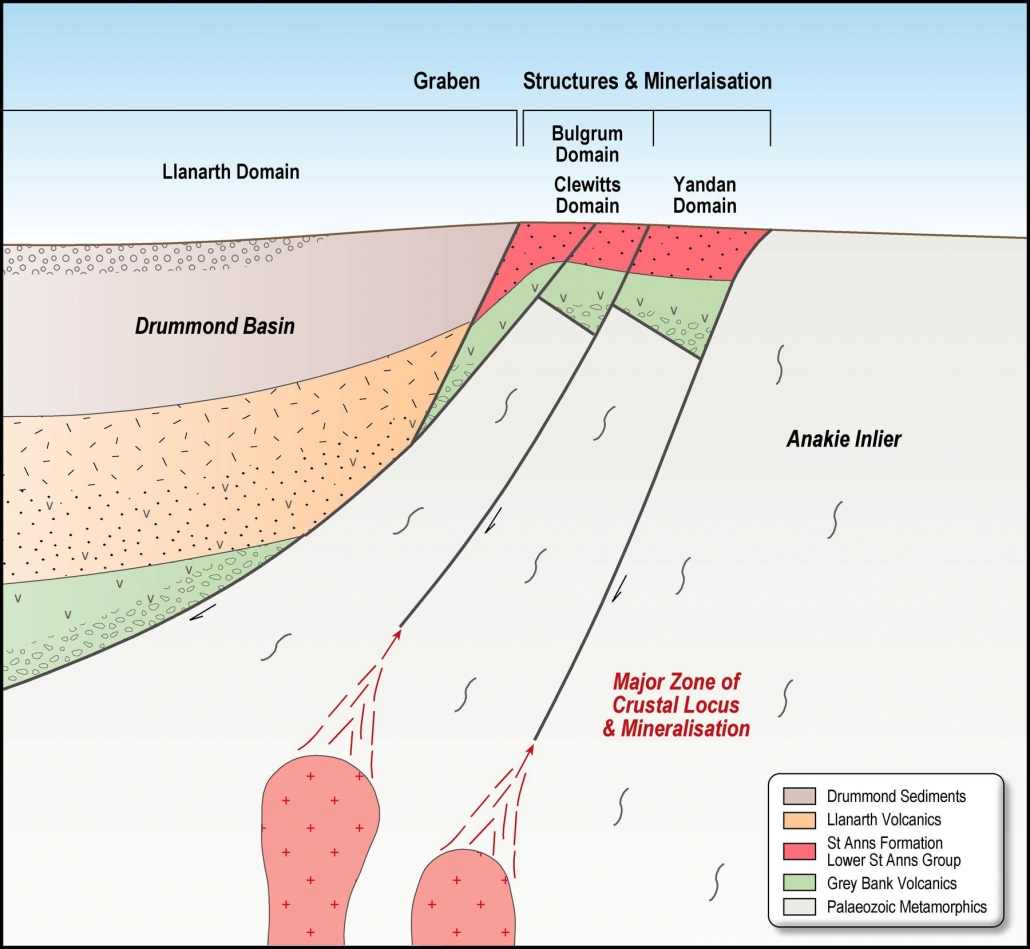
Typically gold mineralisation in the Drummond Basin is associated with epithermal centres and appears to be lithologically and structurally controlled (Figure 13). The gold mineralisation occurs in a well-defined stratigraphic position, often associated with sinters. The mineralisation is fault controlled and has been found using various geochemical techniques. There appears to be two phases of mineralisation, an earlier phase related to epithermal mineralisation and a later economically less significant phase that overprints the epithermal gold mineralisation related to Carboniferous granite intrusion.
Figure 12: Mt Clermont regional geology – Anakie Province/Drummond Basin. (after Withnall & Cranfield 2013)
Figure 13: Drummond Basin Epithermal Gold Deposit Model.
Local Geology
The Mt Clermont Project is located within a prolific epithermal-intrusion related gold-silver belt in central Queensland, host to world class gold deposits such as Pajingo (Vera-Nancy), Mt Leyshon and Mt Wright (Figure 12)
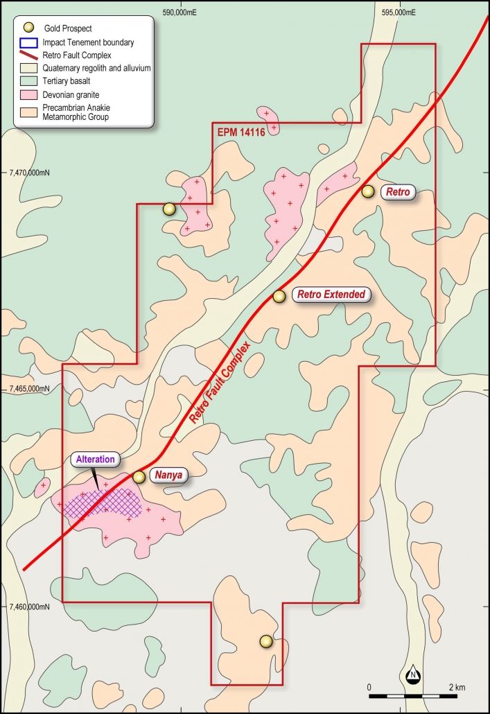
Approximately one third of the Mt Clermont tenement area is interpreted to be underlain by the prospective Cycle 1 Volcanics, beneath a cover of younger Tertiary volcanics and regolith (Figure 14). This cover has hindered previous conventional soil geochemistry surveys although some targets were identified with anomalous gold values.
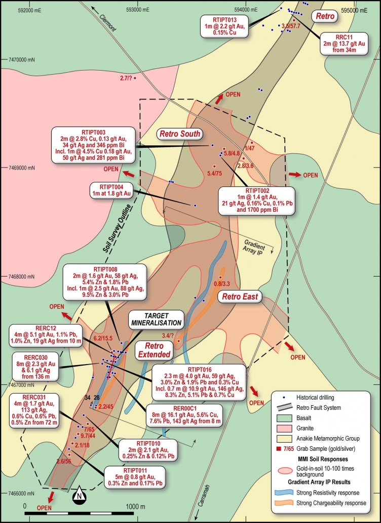
A 2 km long target zone for high grade shoots of epithermal gold-silver-base metal mineralisation was identified by Impact Minerals Limited in 2018-2019. This target was identified from a pattern of strong metal zonation typical of epithermal deposits in drill hole assay data over at least 4 km of strike along the Retro Fault Zone and a high grade gold-silver-base metals intercept at the southern edge of the target (Figure 15).
The metal zonation is characteristic of epithermal mineralisation directly related to magmatic fluids released from a porphyry intrusion of intermediate composition. In addition, the vein system has a strong structural control and the focus of future drilling will be to identify thicker high grade shoots along this Retro Fault Zone.
Figure 14: Mt Clermont local surface geology. (after Impact, 2018)
Historical Exploration
Impact Minerals carried out exploration at Mt Clermont between 2016 and 2019. This work included mapping and collecting grab samples, RC drilling and an IP geophysical survey along the Retro Fault System to confirm the potential for epithermal mineralisation over its 10 km of strike length (Figure 14 and Figure 15).
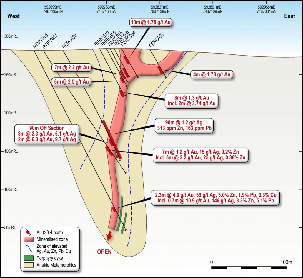
At Retro Extended is a gold-bearing quartz reef/vein system. A mineralised vein system was defined by this drilling over 200 m of strike and 75 m depth (Figure 16).
Impact in 2018 and 2019 drilled 17 RC and one diamond hole for a total of 2,843.5 m along the Retro Fault System as well as rock chip and soil geochemistry and IP resistivity and conductivity geophysical surveys. This work extended the total strike of mineralisation at Retro Extended up to 1,200 m and up to 125 m below the surface.
Exploration Targets
Further mapping, drilling including oriented diamond holes and reinterpreting the geophysics over the entire 10 km Retro Faulting system may lead to a better understanding of the structural controls and identify dilation jogs that may widen and increase the grade of the mineralised lodes with more massive sulphide lenses.
The key target area for future exploration lies in the very poorly drilled area between Retro and Retro Extended including Retro South with a total strike length of 2 kilometres (Figure 15).
The exploration challenge is to find thicker shoots of coherent high grade mineralisation within this target area. It is well known in epithermal veins systems that even subtle changes in dip and strike of the host fault of as little as 5 degrees are enough to cause significant increases in thickness and grade of the ore shoots.
A detailed structural interpretation of the available IP resistivity and conductivity data is planned to identify specific targets for follow up drilling. This work will focus on identifying changes in dip and strike of the host structure which may be a focus for high grade ore shoots.
A follow up drill programme will be designed based on this work. It is likely that close spaced drilling at a maximum of 50 metres between sections will be required along the target area.
At Retro, drilling already completed has located significant gold mineralisation so further drilling, both diamond and RC, is required to help understand its geometry and to test the limits of this mineralisation. To date the mineralization intersected by the drilling has been narrow lode style however pitch and swell structures are quite normal in such a geological environment.
At the Nanya Prospect (Figure 14), located 5 km southwest of Retro Extended at the southern end of the Retro Fault System, a large east trending sericite-pyrite alteration zone with many geological characteristics similar to those at the large Anthony porphyry molybdenum deposit located 100 km to the northwest. This alteration zone on the northern margin of the Retreat Granite is mapped as being at least 1.5 km by 300 m. Grab samples by previous explorers have returned anomalous assays for molybdenum, silver, copper, lead and zinc in the granite as well as in laminated and bladed-textured gossanous quartz veins in sericite altered granite. Gold values were less than 100 ppb. These grab sample results demonstrate this deposit’s potential for large tonnage, porphyry style mineralisation with grid RC drilling planned to determine this deposit’s grade and dimensions.
Figure 15: Geology and exploration results for the Retro-Retro Extended Prospects. (after Impact, 2019)
Figure 16: Section 7,467,200N. Geology and drill hole assays. (after Impact, 2019)

