May Queen Gold Project
Location and Tenure
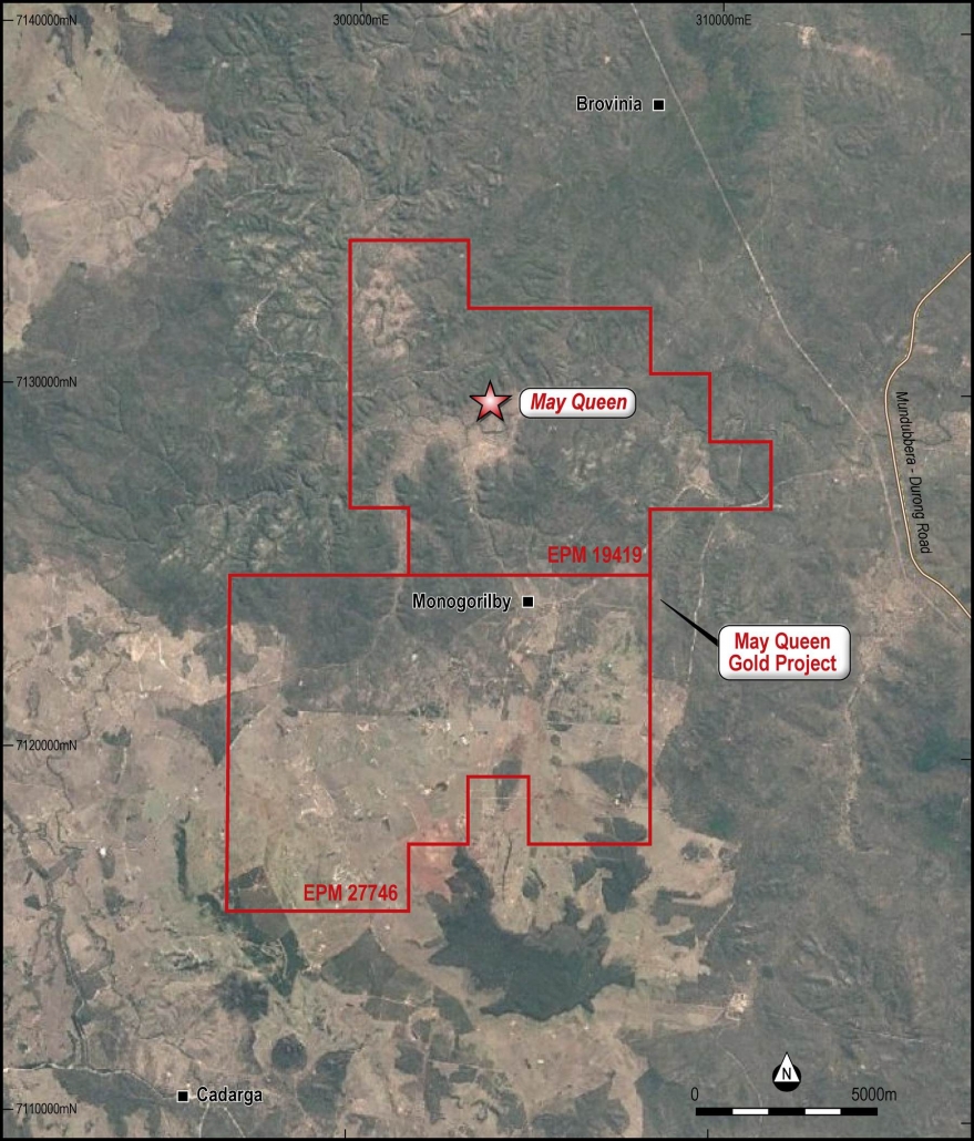
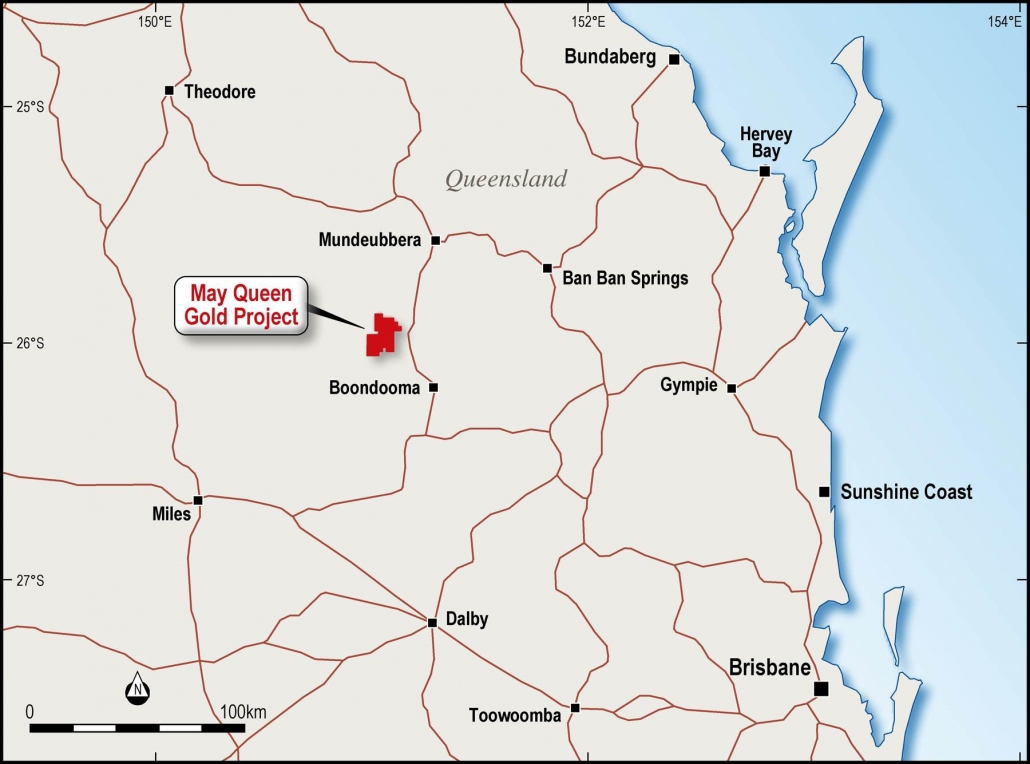
The May Queen gold project comprises granted tenement Exploration Permit for Minerals EPM 19419 and adjacent application EPM 27746, located within the Brovinia goldfield in Queensland, approximately 225 km by road south-west of the nearest regional port at Bundaberg and 375 km by road from Brisbane (Figure 3). It covers free-hold land with no Native Title claim.
The May Queen tenement is accessible by well-maintained gravel tracks leading off the nearby bitumen Mundubbera-Durong Road. Access is possible all year except after occasional summer tropical storms when roads may be blocked due to flooding for short periods.
Figure 2: May Queen tenements – EPM 19419 and EPM 27746. (after GoogleEarth)
Figure 3: May Queen location.
Physiography and climate
The Mundubbera region that includes the project area comprises a continental landscape of hills, valleys, plateau and plains. The climate is subtropical without a distinct dry season, although most rain falls during the summer. The average annual rainfall is about 670 mm (Bureau of Meteorology, 2000). Stream erosion has been a major factor in the evolution of the landscape and has produced incised topography over much of the area.
The region includes two major drainage networks; the Dawson River with its system of westward and northward tributaries in the west, and the Burnett River with its system of southward and eastward tributaries including at May Queen in the east. The drainage divide is principally at 400–450 m above sea level (ASL). The valley floors in the east are at about 150–250 m ASL, whereas in the west they are at about 200–250.
The project area consists of a plateau formed from Tertiary volcanics and Jurassic sediments incised by the Monoyorilby, Fishy and Brovinia Creeks and tributaries producing a topographic range between 250 mRL in the valleys and 350 mRL on the plateau.
Regional Geology
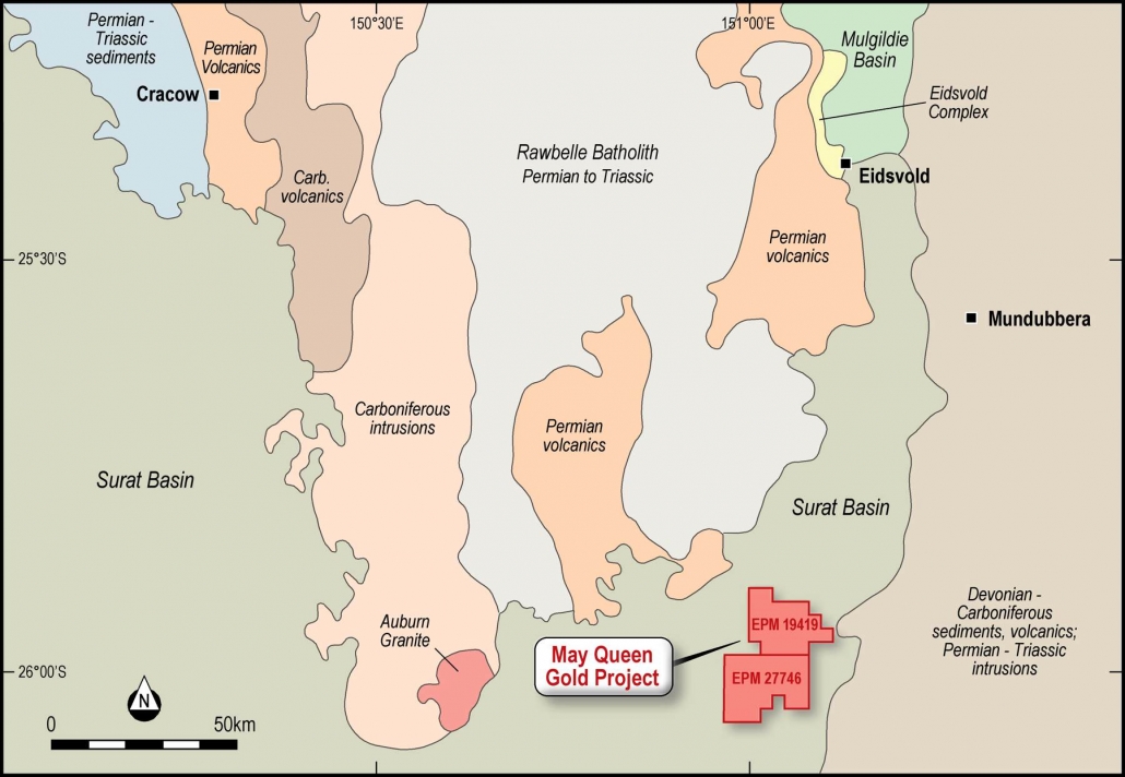
The bedrock geology of the Mundubbera and northern part of the Chinchilla 1:250,000 scale geology sheets comprises a series of north-trending zones (Figure 4).
Progressing from east to west, these are as follows:
• Steeply dipping Devonian to Carboniferous rocks in the east related to a former subduction zone and forearc basin. Also in this area are a number of Permian to Triassic intrusions and several Tertiary basalt flows.
• Immediately to the west is a narrow zone of Jurassic sediments (Mulgildie Basin in the north; Surat Basin in the south).
• Permian to Triassic intrusive rocks of the Rawbelle Batholith dominate the central part of the region. This batholith comprises granite, granodiorite, adamellite and gabbro. The Eidsvold Complex also forms part of the Rawbelle Batholith, and is the host for gold mined in the Eidsvold area.
• Carboniferous intrusions fringe the Rawbelle Batholith in the west. These comprise granodiorite and adamellite.
• Upper Carboniferous and Permian volcanic rocks occur west of the Carboniferous intrusions, and also along the eastern margin of the Rawbelle Batholith, near Eidsvold. In the west they comprise the Camboon Volcanics (Bowen Basin), which host the Cracow gold deposits.
• Lower to Middle Jurassic sediments of the Surat Basin are exposed in the western and southwestern parts of the Mundubbera sheet area and include the May Queen project area. These rocks dip very gently to the southwest and include the Precipice Sandstone at the base of the sequence, overlain firstly by the Evergreen Formation, then the Hutton Sandstone, and then the Injune Creek Group.
• Westerly dipping sedimentary rocks of the Bowen Basin are present in the northwest of the region. These comprise the Permian Back Creek Group (mudstone, sandstone, limestone), and the Lower Triassic Rewan Formation (sandstone and finer grained rocks).
• Overlying the Permian to Triassic intrusive rocks in the centre of the region is an extensive but thin Cenozoic sandstone with a variably preserved ferruginous cap. An erosional scarp commonly marks the perimeter of the Cenozoic sandstone thereby forming the “Central Plateau”, and a pediment of mottled saprolite extends from its base. To the east of the Central Plateau are numerous knolls and mesas of sandstone resulting from incomplete erosion of a formerly more extensive sand sheet.
Figure 4: May Queen regional geology. (modified after Jones 2003)
Local Geology
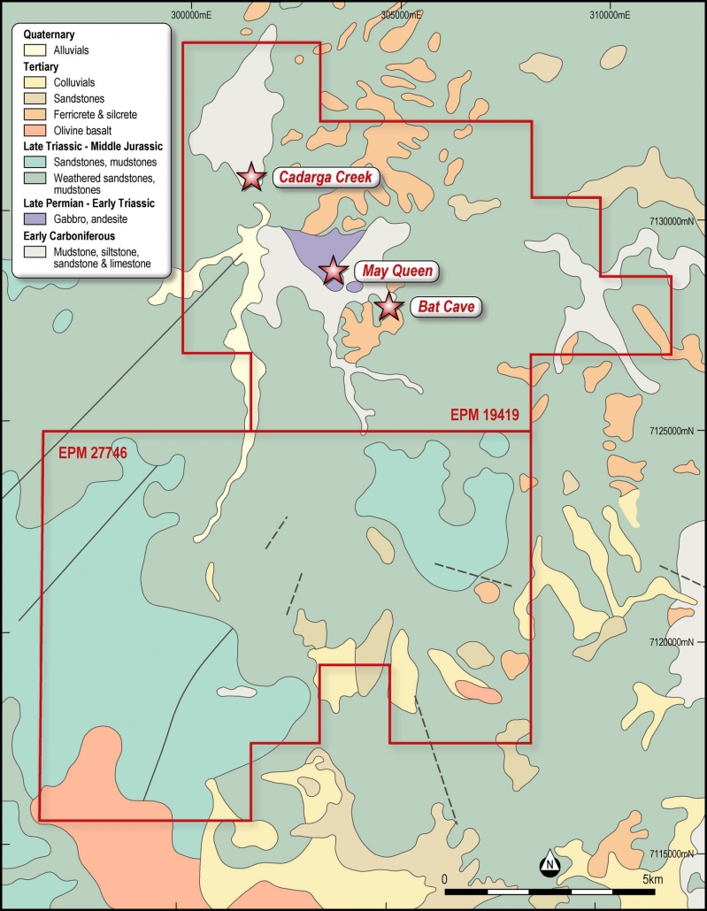
The May Queen Project tenements lie at the junction of the Mundubbera and Auburn, 1:100,000 scale geology maps (Figure 5).
The major portion of the tenement area is covered by a relatively flat lying sequence of variable sandstones, pebbly sandstones and shales of the Jurassic Evergreen Formation (Figure 5). These sediments form a sharply dissected plateau with a basal unconformity exposed in the valleys at an elevation of approximately 280 mRL.
Below the unconformity is a west to north-west trending sequence of acid tuff, greywacke and mudstone with minor flow banded rhyolites. This sequence is tentatively correlated with the Carboniferous Torsdale Beds which occur some 65km to the west, and on the opposite side of the Permian Auburn Complex. The presumed Torsdale Beds contain two main suits of intrusives;
- the dioritic to granodioritic stock hosting the May Queen deposit and associated, extensively clay altered felsic intrusives to its immediate southeast,
- smaller northwest-southeast trending stocks of aphyric to porphyroidal rhyolite and quartz-feldspar porphyry.
The Torsdale Beds appear to be broadly folded into a northeast trending syncline. The northwest-southeast control on the emplacement of the porphyroidal intrusives appears to post-date the folding. A number of well-defined topographic breaks in the Evergreen Formation suggest that later faulting has occurred along a parallel northwest-southeast trend.
Exploration to date within EPM 19419 has been focussed on Carboniferous hosted gold mineralisation exposed in valleys associated with various creeks beneath a veneer of the Early Jurassic Evergreen Formation volcanics and sediments.
At May Queen Gold the mineralisation occurs along the contact zone and in close proximity to the porphyry dykes. In detail, the gold lies within quartz chalcedony veinlets within a few metres of the porphyry contacts. Sulphide contents are generally less than 1% and there is a broad correlation with tellurium in the chemical analyses. This is typical of the epithermal gold occurrences that appear in this district including at the Cracow mine.
Copper ‐ gold (potential ‘skarn’ type mineralisation associated with copper‐gold porphyries) was intersected in the northeast of the prospect where surface copper oxide staining had been recognised in reconnaissance mapping.
The May Queen deposit is characterised by a discrete magnetic anomaly also spatially associated with historical drill intersections (Figure 9). Several additional small magnetic anomalies occur to the south‐east of the May Queen prospect under approximately 20 m to 50 m of younger Tertiary cover. Potential exists for the discovery of additional high‐grade gold mineralisation similar to May Queen at these aeromagnetic anomalies.
Figure 5: May Queen local geology. (after GSQ, MUNDUBBERA 1:100,000 sheet)
Historical Exploration
The May Queen mine was part of the Brovinia gold field and was described by Jack (1896).
The first modern exploration was undertaken by Burmine (ATP 4106) who carried out reconnaissance mapping and rock chip sampling. They took 112 samples with one assaying >1 ppm Au.
Black Swan (ATP 4576) explored the area during 1987-1988. In this period they completed gridded auger soil sampling, rock chip sampling, costeaning, ground magnetic and EM surveying and geological mapping. The company also drilled 15 RC holes, eight of which tested the May Queen mineralisation, Table 4. This work returned several narrow but very high grade results, the best of which was a one metre sample which assayed 149 g/t Au (BPH01). The other holes were drilled at Bat Cave (four holes), Bracken Valley (two holes) and one hole designed to test a skarn altered outcrop to the north of May Queen. This drilling was carried out prior to JORC Code (2012) and so the results are provided as an indicative guide only as these results cannot be independently verified.
Table 4: Black Swan drill intercepts summary.
|
Hole ID |
East |
North |
RL |
Dip |
Azimuth |
Total Depth (m*) |
From (m*) |
To (m*) |
Width (m**) |
Average Au g/t# |
|
BPH01 |
303549 |
7128702 |
266 |
-60 |
196 |
70 |
32 |
34 |
2.0 |
75.40 |
|
BPH02 |
303548 |
7128660 |
266 |
-60 |
155 |
64 |
10 |
15 |
5.0 |
0.29 |
|
BPH03 |
303579 |
7128787 |
266 |
-60 |
232 |
55 |
No significant intersection |
|||
|
BPH10 |
303545 |
7128700 |
266 |
-60 |
233 |
14.5 |
12 |
13.5 |
1.5 |
0.26 |
|
BPH11 |
303547 |
7128659 |
266 |
-60 |
53 |
15.5 |
4 |
5 |
1.0 |
8.30 |
|
BPH12 |
303549 |
7128707 |
266 |
-60 |
233 |
38 |
18 |
19 |
1.0 |
3.52 |
|
and |
31 |
32 |
1.0 |
5.34 |
||||||
|
BPH13 |
303538 |
7128667 |
266 |
-60 |
53 |
37 |
14 |
15 |
1.0 |
1.89 |
|
BPH14 |
303554 |
7128699 |
266 |
-60 |
233 |
47 |
10 |
12 |
2.0 |
1.00 |
|
and |
36 |
37 |
1.0 |
9.00 |
||||||
|
BPH15 |
303542 |
7128715 |
266 |
-60 |
233 |
25 |
9 |
12 |
3.0 |
18.86 |
|
and |
21 |
25 |
4.0 |
38.80 |
||||||
NOTE: * Down hole depths,**intersection widths are down hole, not true widths, # Grade intercept thresholds are >=1 m and >=1 g/t.
During 1997 Compass Resources (EPM 11197) carried out further soil, rock chip and BCL drainage sampling around the May Queen prospect.
Copper Strike (EPM 15036) in joint venture with Paradigm Gold drilled a further seven RC holes at May Queen. The company also surveyed in the Black Swan drill collars.
Two holes were located close to previous high-grade results reported by Black Swan but the results failed to duplicate the high grades or widths of the previous drilling campaign (Table 5). This drilling was carried out prior to JORC Code (2012) and so the results are provided as an indicative guide only as these results cannot be independently verified.
Table 5: Paradigm Gold drill intercept with gold assays summary.
|
Hole ID |
East |
North |
RL |
Dip |
Azimuth |
Total Depth (m*) |
From (m*) |
To (m*) |
Width (m**) |
Average Au g/t # |
|
BVP001 |
303524 |
7128709 |
266 |
-60 |
53.5 |
70 |
15 |
17 |
2 |
1.68 |
|
BVP002 |
303545 |
7128716 |
266 |
-60 |
233.5 |
35 |
10 |
11 |
1 |
1.31 |
|
BVP003 |
303511 |
7128730 |
266 |
-60 |
53.5 |
40 |
28 |
32 |
4 |
0.53 |
|
BVP004 |
303519 |
7128672 |
266 |
-60 |
53.5 |
77 |
44 |
46 |
2 |
4.67 |
|
and |
53 |
54 |
1 |
22.9 |
||||||
|
BVP005 |
303541 |
7128640 |
266 |
-60 |
53.5 |
65 |
43 |
44 |
1 |
0.07 |
|
BVP006 |
303477 |
7128770 |
266 |
-60 |
53.3 |
65 |
54 |
55 |
1 |
0.06 |
|
BVP007 |
303561 |
7128600 |
266 |
-60 |
53.5 |
60 |
38 |
39 |
1 |
0.06 |
NOTE: * Down hole depths,**intersection widths are down hole, not true widths, # Grade intercept thresholds are >=1 m and >=1 g/t.
The project area was acquired by IronRidge Resources (EPM 19419) in 2014, primarily to test for extensions to the titanium (rutile) mineralisation outlined in the Tertiary volcanics in the Monogorilby area. Subsequently the potential for Tertiary hosted rutile (and bauxite) mineralisation was downgraded and attention focussed on the May Queen prospect.
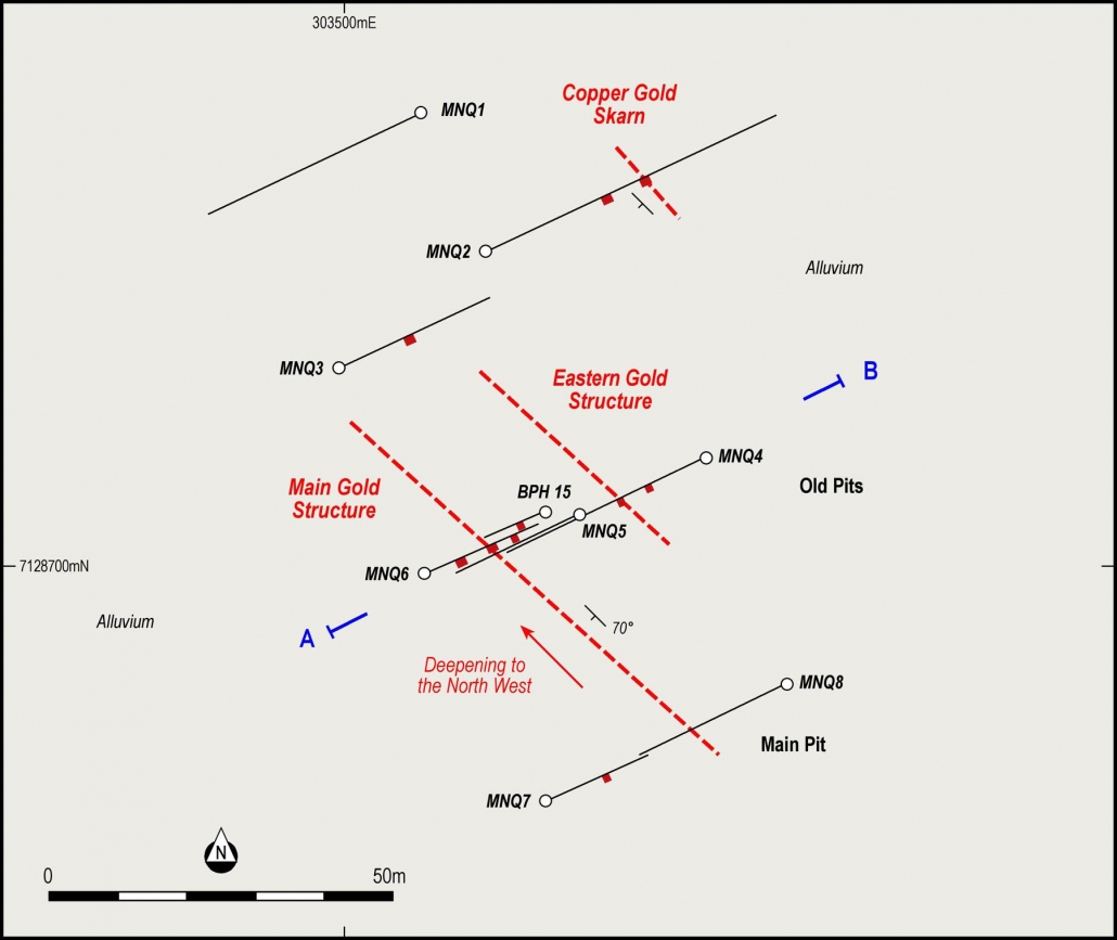
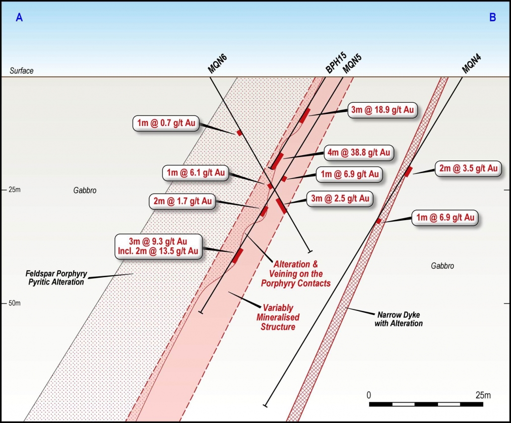
A total of 85 soil and three rock chip samples were collected within the May Queen prospect area by IronRidge. The following year an eight hole RC drill program was completed aimed at testing previous high grade drill intercepts and outlining possible extensions to the known mineralisation, Table 6. The best grades were reported from MQN5 which intersected several narrow mineralised zones between 25-49m, with a best assay of 46-48m @ 13.5 g/t Au. It is likely that the enhanced width and tenor of mineralisation is due to the fact that the hole was drilled sub-parallel to the dip of the lode.
Table 6: Iron Ridge Resources drill intercept summary.
|
Hole ID |
East |
North |
RL |
Dip |
Azimuth |
Total Depth (m*) |
From (m*) |
To (m*) |
Width (m**) |
Average Au g/t # |
|
MQN1 |
303514 |
7128784 |
259 |
60 |
235 |
85 |
No significant intersection |
|
||
|
MQN2 |
303528 |
7128759 |
259 |
60 |
55 |
121 |
46 |
47 |
1 |
0.62 1.3% Cu |
|
MQN3 |
303499 |
7128735 |
260 |
60 |
55 |
60 |
29 |
30 |
1 |
0.72 |
|
MQN4 |
303566 |
7128721 |
260 |
60 |
235 |
85 |
24 |
26 |
2 |
3.45 |
|
MQN4 |
|
|
|
|
|
and |
37 |
38 |
1 |
6.95 |
|
MQN5 |
303543 |
7128711 |
260 |
60 |
235 |
61 |
25 |
26 |
1 |
6.86 |
|
MQN5 |
|
|
|
|
|
and |
34 |
36 |
2 |
1.71 |
|
MQN5 |
|
|
|
|
|
and |
46 |
49 |
3 |
9.27 |
|
MQN6 |
303515 |
7128698 |
260 |
60 |
55 |
46 |
28 |
29 |
1 |
6.14 |
|
MQN6 |
|
|
|
|
|
and |
33 |
36 |
3 |
2.58 |
|
MQN7 |
303537 |
7128657 |
262 |
60 |
55 |
42 |
24 |
26 |
2 |
0.73 |
|
MQN8 |
303580 |
7128678 |
260 |
60 |
235 |
67 |
No significant intersection |
|||
NOTE: * Down hole depths,**intersection widths are down hole, not true widths, # Grade intercept thresholds are >=1 m and >=1 g/t.
Figure 6: Drill and trench location plan showing lode intercepts at May Queen. (after IronRidge)
Figure 7: Interpreted cross section AB. (after IronRidge)
Exploration Targets
The main feature of the May Queen Project is that the majority of the area is covered by barren Tertiary sediment cover. The only window through these sediments where the target geology outcrops is along the deeper valleys, most notably around the May Queen workings.
The immediate exploration target is in the vicinity of the May Queen mine (Figure 6 and Figure 7) where there is no Tertiary cover and drilling completed to date has intersected significant intersections of potentially ore grade (Table 6). Most of the historic drilling intercepts with high grades are less than 50 m vertically from the surface. The first focus of the future exploration will be validation of the previous drilling, including some twinning of selected historical holes, as well as stepping back to test the down dip extensions of the shallow high grade gold mineralisation (Figure 8) as well as drilling along strike in an effort to establish a JORC Code (2012) compliant resource estimate.
The verification drilling will be focused on previous high grade intercepts including 4 m at 38.8 g/t in BPH15 from 21 m (Table 4). This first phase of verification and resource extension drilling will amount to approximately 1,200 m of diamond drilling. The diamond core will be oriented to provide extra structural information on the mineralisation. This drilling will be performed under the supervision of a qualified geologist following current best drilling, sampling and QA/QC practices. If the verification drilling assays compare well with the original drill data the historical drill database can be confidently used to establish a JORC Code (2012) compliant resource estimate report.
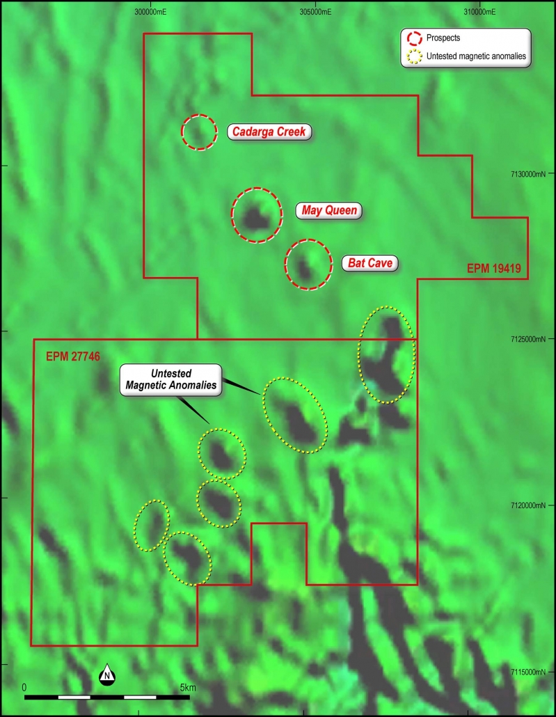
Potential also exists for the discovery of additional high‐grade gold mineralisation similar to May Queen at other untested aeromagnetic anomalies of similar dimensions and intensity as May Queen (Figure 6). This exploration will entail RC drilling aimed at the magnetic anomalies through the Tertiary sediments. Detailed field mapping and sampling is recommended along the southern magnetic anomalies to ascertain if there are any surface expressions to assist in the next phase of work.
Cadarga Creek, May Queen and Bat Cave occur along a northwest striking aeromagnetic structure over a strike length of 1.3 km (Figure 9). Most of the historical drilling has been at May Queen while anomalous rock chip samples have been taken in Bat Cave. This newly identified potentially mineralised structure will be followed up with geological and structural mapping and a geochemical survey to determine its prospectivity.
Potential also exists for additional high‐grade gold mineralisation similar to May Queen at untested aeromagnetic anomalies of similar dimensions and intensity as May Queen on EPM 27746 application, below the Late Triassic-Middle Jurassic sediment cover, as shown in Figure 9. These magnetic features could be linked to magnetite-bearing skarns. This exploration will entail deep RC drilling aimed at the magnetic anomalies through the overlying sediments. Detailed field mapping and sampling is also recommended along the southern magnetic anomalies to ascertain if there are any surface expressions to assist in targeting this drilling.
Figure 8 Proposed drilling at May Queen Gold Project.
Figure 9: Aeromagnetics at May Queen.

