Mt Peake Lithium Project
Location and Tenure
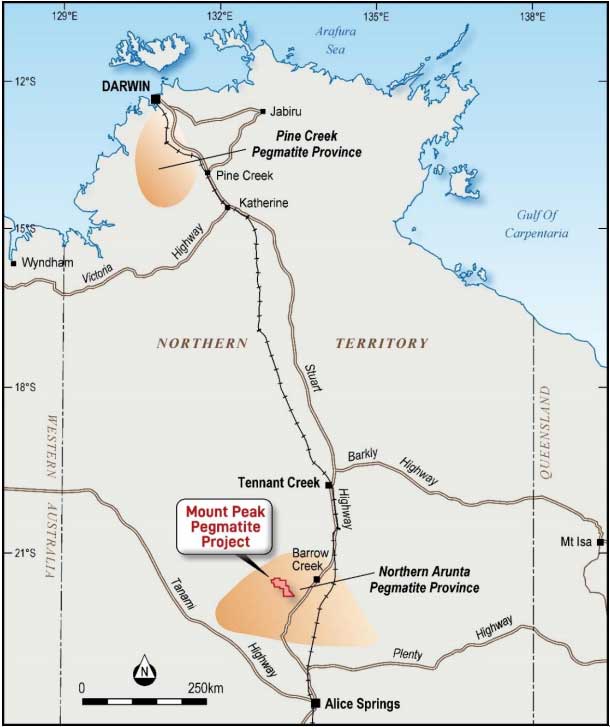
The Mount Peake Pegmatite project is located within the Northern Arunta pegmatite province approximately 200km north of Alice Springs and 250km south of Tennant Creek along the Stuart Highway in the Northern Territory.
There are several key features attracting our attention:
- The project area is in the Anningie Sn- Ta pegmatite field which is a known LCT pegmatite district in Central Northern Territory.
- The Esther granite contains biotite-muscovite granite, leucocratic, medium-grained, even-grained to porphytic, tourmaline bearing, pegmatite and aplite (Offe,1978). These mapping works were conducted through on vehicle and foot traverse observations according to the 1: 250,000 scale geological map of Mt Peake (Donnellan, 2008).
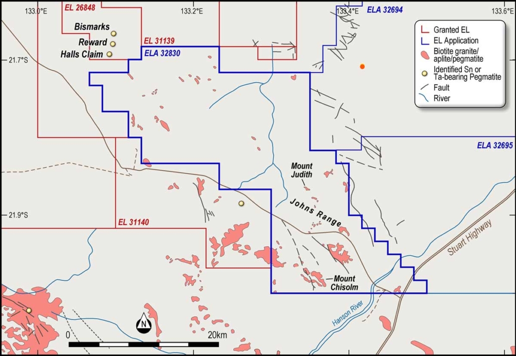
- There is Sn,Ta-bearing coarse-grained Paleoproterozic pegmatite identified in Reward Tin Prospect in the surface, 70 m long and 5-20 m wide, which is located 3 km to the north of the ELA 32830. According to the geochemical analysis by Frater (2005), three reward pegmatite samples were assayed with results of up to 747 ppm Li. Similar pegmatites have been identified across ELA32830.
- Lepidolite (Li-bearing mica) and spodumene were identified in pegmatite sample by petrological examination in 1965 by Pontifex. The location of this sample is ~7 km east of ELA 32830, marked in Figure 2.
- Tenement Application covers the Stuart Highway and 30 Km to the Central Australia Railway, which provides excellent logistic support for the project down the track.
Figure 1: Project location in the Northern Arunta Pegmatite provinces of the Northern Territory (KM Frater, 2005)
Figure 2: the location of ELA 32830. It shares a boundary with EL26848 and EL 31139 which are owned by Core Lithium Limited (ASX:CXO). This entire area is in the Anningie Sn-Ta Pegmatite field. Location of lepidolite and spodumene minerals have been identified in 1965 by Pontifex is marked with red dot.
Previous Exploration
The Anningie tin field, covering the Company’s license application, has historically been explored for tin/tantalite since 1935. While regional mapping of the district has been carried out by the Northern Territory Geological Survey, the area covered by ELA32830 is essentially unexplored. In 1965, a mineralogy examination of a Li-bearing pegmatite in the Anningie Tin field was conducted, with lepidolite (Li-bearing mica) and spodumene identified in a thin section study (Pontifex, 1965).
The Anningie Tin field occurs within intrude mica schists and amphibolites of the Lander Rock beds in the foothills of uplands draining into Anningie Creek, a tributary of the Hanson River. Tin-tantalum-bearing pegmatites intrude mica schists and amphibolites of the Lander Rock beds in Mount Peake. In 1998,Adelaide Resources NL explored the area for Tennant Creekstyle and Granites Tanami-style gold deposits (Howard, 1998). A total of 244 vacuum drilling holes were drilled using 1.6 km by 800 m spacing, totalling 1,220m, with some of the drilling carried out in the Company’s application area. Granite, granite gneiss, schist and amphibolite were intersected, usually below think regolith development.
Upcoming Exploration
At the Mount Peake pegmatite field, the Company will shortly conduct field reconnaissance and geological mapping using the 1:250,000 scale Mt Peake geological map. In the meantime, the Company is exploring innovative techniques, like remote sensing interpretation, to narrow down pegmatite outcrop which could be potential hosts of lithium mineralisation.


